With the completion of my bachelor’s degree only a few weeks away (exciting!) I want to celebrate the past five years’ hard work with a multi-day bike tour. There is a lot going on in the meantime, however, both in my own life and in the broader world:
- I live in Victoria, Australia, where the current coronavirus situation has us under strong government restrictions, and Victorians are barred from entering other states.
- I live in a regional area, which means I can travel to other regional areas within my own state.
- I can only leave my family for a few days at a time, as I have kids.
- I’ve just recently (this past June) purchased a brand new Surly Disc Trucker touring bike, which I’m super keen to take on a large ride and break in properly.
With all that in mind, and given my deep love for the Murray River, I’m planning on a trip between Swan Hill and Echuca — towns on the Murray River, which forms the border between Victoria and New South Wales. As such I will have to keep to the “Victorian” side of the river1 to not run afoul of COVID-19 regulations. I will catch a train from Melbourne to Swan Hill, ride along the Victorian side of the Murray to Echuca, then another train back to Melbourne.
Mapping out the route
Online mapping services
There are lots of mapping applications and services available these days, and there are an equal amount of “listicles” detailing all their respective merits, so I’m not going to do that. I used the RideWithGPS Web Route Planner as it suited my way of doing it for this ride. Sometimes I use Google Maps. Other times I use OpenCycleMaps. I tend to jump around from service to service on a ride-by-ride basis.
The most difficult aspect of online mapping services in my experience is the routing along roads. Despite some good efforts on the part of services like RideWithGPS, Komoot, and others, there are still serious limitations to the AI behind routing along cycle paths and anything “non-car”. Especially along routes such as this one — riding along the Murray River, bush tracks and gravel roads and farm fencing to dodge — the limitations of the routing engines start to really show. I’d love to see a “let me explore” option on some of these services: something that lets you say, “your navigation isn’t suiting me/is inaccurate/road’s blocked/etc, I want to venture off the planned track, but let me know if I get x kilometres too far from the plotted route”…
Offline paper maps
Due to the nature of the Australian landscape, limitations of battery-powered devices, and some bad experiences in the past with ‘broken’ directions from online maps, I always carry a paper map. Sometimes, like with my trip to Adelaide last year, this involves carrying many maps to cover a long route. Not only does this present storage problems, but paper maps are increasingly disappearing from print/being discontinued in favour of electronic GPS. This time I got lucky and am using Hayman’s Cohuna–Echuca–Gunbower Forest Activities Map (2nd ed.), a 1:50,000 scaled camping and touring map that covers the route from Murrabit to Echuca, and shows all the riverside tracks and dirt paths in the various state forests along the way.
Swan Hill to Echuca: Planned route along the Murray
Gear and equipment
Accommodation
With a key focus on weight, I’ve travelled before with my very lightweight and compact DD Jungle Hammock. Unfortunately river red gums — although incredibly beautiful and perhaps my favourite tree — are notorious for dropping branches, especially in the humidity of springtime and summer. Therefore hanging a hammock under a red gum is probably not the best idea.
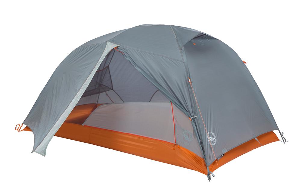
Dilemma: I have plenty of tents/swags but they are not light or compact, so it seems I’m in the market for yet another tent to add to my sizeable range. This has caused a little consternation from the better half, and I find myself stuck between wanting a budget option to keep Danielle happy that we didn’t spend a bundle; or rather opting for a solid, dependable and durable quality tent so I only have to weather the argument once. ?
In the end, I chose to pay once and get something good, and I’ve read good reviews of the Big Agnes Copper Spur HV UL2 Bikepack tent, which seems to be the same as their Copper Spur HV UL 2 but with a shorter pole-set and a handlebar-suitable carry sack. The guys at Backpacking Light in Lt. Bourke Street Melbourne sorted me out over the phone, and reassured me that if I wasn’t happy with the tent — I’m a bit nervous buying a tent sight unseen — I could return for a refund no worries. Now I’m just waiting on the mailman…
Scheduling
Tour length
I can only fit in 5–6 days, mid-week, so as not to neglect family obligations. The planned route is about 200 kilometres, so I figure on riding an average of 50km a day for 4 days’ riding, plus travelling there and back (a few hours each way on the train). I have two camping preferences before I go: near Torrumbarry in a place I always camp at with some mates each year, and near Bailleau Lagoon (at the end of Young’s Road near Echuca) where I often camp with Danielle. Of course, the best part of the Murray is the abundance of camping everywhere, so I’m happy to be a bit flexible as well. 50 kilometres per day is nice easy riding, so I can stop often, enjoy the ride and have plenty of down time at camp.
Tour timing
As said above, at the end of my exam period (about mid-November) to mid-December (when the kids start school holidays) is my ideal window for getting in some river-time. Other considerations are bushfire alerts, which are becoming increasingly concerning every year, but to be honest I’m not too worried about given the proximity to towns and services, and the weather. Given the family obligations it looks increasingly likely that I will need to just head out regardless of rain, hail or shine.
Bike preparation
My bike is brand new and in tip-top shape, so it’s really just tyres, some basic spares and working out how I’m going to “rig” the bike. I’ll have racks and panniers front and rear with my tent on the handlebars, and I’m hoping to squeeze on a few fun things such as a fishing rod, and strapping my solar panel to the rear rack.
I’ll then do a 30–40km dry run around Ballarat with gear attached just to make sure everything’s sweet before heading off.
Getting there and back
The plan at this stage is to catch a train from Melbourne to Swan Hill, and then from Echuca back to Melbourne, but of course I’m not sure what the COVID rules are and the info on V‑Line websites and such is not very clear. It’s easy to find out what you can and can’t do if travelling to or from Melbourne, but not via Melbourne. If I can’t manage a train journey there and back, I might have to retrace my journey back to Swan Hill and drive.
- Both banks of the Murray River are technically in New South Wales as the state has jurisdiction over the entire river. A fun little fact that gets a lot of Victorian fishermen in trouble each year when they buy Vic fishing licenses but are unwittingly fishing in New South Wales.